OSGeo Code Sprint Bolsena 2012
2012-06-16 22:35
The OSGeo Code Sprint in Bolsena/Italy was great. Many interesting people sitting the whole day in front of their laptops surrounded by a beautiful scenery. This year I spent most of my time on GeoCouch, CouchDB, Couchbase, deegree, Imposm and GeoNetwork.
Already on the first hacking day we had a result, a Couchbase backend for the deegree blob storage. This means that you can now store your rich features (e.g. from INSPIRE) in Couchbase and serve them up as a WFS with deegree. In case you wonder what rich features are, it's the new, shiny and more descriptive name for complex features.
In the following days I worked together with Oliver Tonnhofer on a CouchDB/GeoCouch backend for Imposm. You are now able to store your OpenStreetMap data in CouchDB and make queries on it through GeoCouch. I've created a small demo that displays the some data import from Andorra with directly with MapQuery, without the need of any additional server/service. The CouchDB backend should be easily adaptable to Couchbase, if you want to help, let me know.
I've then spent some time on the GeoNetwork project and helped translating the language file to German. I cleaned it up a bit and fixed major wrong translations. It's not perfect yet, as I've only spent little time on it, but at least it should be way more understandable (and sadly less funny) than the original version which was generated by Google Translate.
When it was time for presentations, I give a quick overview over the Couch* ecosystem. From CouchDB to GeoCouch, BigCouch, PouchDB, TouchDB (TouchDB-iOS, TouchDB-Android), Couchbase Syncpoint and Couchbase. You can find the slides as PDF here.
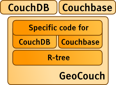
On the last day I've spent my time on polishing GeoCouch a bit and getting it ready for the Couchhack in Vienna. I've backported all changes from Couchbase to the CouchDB 1.2.x branch and also ported the geometry search into an experimental branch. You can now search your GeoCouch with any Geometry GEOS supports.
The event was fun as always and I also get to know some new people (hello B3Partners guys). Thanks Jeroen from GeoCat for organizing it, and thanks all other hackers that made it such a awesome event. Hope to see you all next year!
Categories: en, GeoCouch, CouchDB, Couchbase, conference, geo